Compass
Production date
Late 18th Century
See full details
Object detail
Description
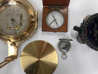
Round compass with screw top lid, engraved with its history on the top of the lid. Inside the lid, the decorative bearings are printed on card in ink. The lid itself is slightly bent. The compass card in the base of the housing is decorated in a similar fashion to that on the lid, and is attached to a pivot and shadow pin.
Classification
MARITIME TECHNOLOGY Navigational Instruments compass
Production date
Late 18th Century
Measurements
Base: H27 x Diam 70 mm
Lid: H7 x Diam 70 mm
Lid: H7 x Diam 70 mm
Media/Materials description
Brass, cardboard
Signature/Marks
Presented to Jas. Dent, master mariner, by a seaman who carried it with him, while engaged in the service of Captn. Cook during his voyages round the world, presented again by Mrs Dent, relict of the above J. Dent to David J. Christison, Berwick 1840.
History and use
Bearing compasses like this were in use from the early 18th century and determined direction in relation to the Earth's magnetic poles. This compass is believed to have belonged to a seaman who accompanied Captain James Cook on his voyages.
Captain James Cook (7 November 1728 - 14 February 1779) gained fame as a cartographer and explorer making three major voyages in the name of the British crown.
The first beginning in 1768 intended to record the Transit of Venus and investigate the rumour of a southern landmass. The expedition made its way to Tahiti to record the celestial occurrence before turning south to search for land mass in the South Pacific. With the help of the Māori people Cook charted the coastline of New Zealand but not all their exchanges were peaceful. Foreshadowing many of the violent interactions that Cook and his crew had with Indigenous people across the Pacific, they were responsible for the deaths of at least 8 Māori people on this voyage.
HMS Endeavour then sailed for Australia's east coast travelling north and mapping the coastline before coming ashore on the land of the Dharawal people of the Eora nation (Botany Bay). Here the crew interacted with a group of Indigenous men. The exchange was violent as the Indigenous people tried to defend their home. The expedition continued north, up the east coast of Australia, where Cook made the most extensive European documentation of the country to that date. After making it all the way to the top of Australia's eastern coastline Captain Cook claimed ownership of the newly charted landmass for England. A claim that would have serious repercussions through history. The ship returned to England in 1770.
The second voyage on the HMS Resolution in 1772 was another attempt to further chart a southern landmass which saw Cook reach the Antarctic Circle, Tahiti, Islands of Tonga, Easter Island, Norfolk island, New Caledonia and Vanuatu. He arrived back in England in 1775.
The third voyage in 1776 aboard the HMS Resolution had the goal of finding a more northern route to the Americas. He landed in Hawaii before making his way up the west coast of America to Canada and Alaska before returning to Hawaii in 1779. Quarrels soon broke out between Cook's crew and the Hawaiians due to thefts and violence between the groups. Cook attempted to diffuse the situation by kidnapping the Ali'i nui, Kalaniʻōpuʻu-a-Kaiamamao, leading the monarch back to his ship. The Hawaiians realising Cook’s intention struck him and stabbed him. He died in the shallows on the beach.
The legacy Cook leaves is a conflicting one. Though he undoubtedly advanced our geographical understanding of the world, his name symbolises colonialism and the lasting effect that British colonial greed and ignorance had on Indigenous peoples across the globe including Australia.
Associated person
Registration number
H272